Logo Logo Logo Logo Logo
  • Company
  • Technology
    • Technology
    • MAPPING AND AERIAL PHOTOGRAMMETRY
    • LASER SCANNER
    • LIDAR
    • MOBILE MAPPING
    • SOFTWARE
  • Services
    • Services
    • TOPOGRAPHY AND CIVIL ENGINEERING WORK
    • INFRASTRUCTURES INSPECTION
    • POWER LINES
    • MINING QUARRIES
    • PRECISION FARMING
    • SPATIAL PLANNING (G.I.S)
    • ENVIRONMENT
    • FOREST APPLICATIONS
    • LANDSCAPE APPLICATIONS
    • PHOTOGRAPHIC AND AUDIOVISUAL WORKS
  • PROJECTS
  • CONTACT
  • English
    • Français

Topography and Civil Engineering

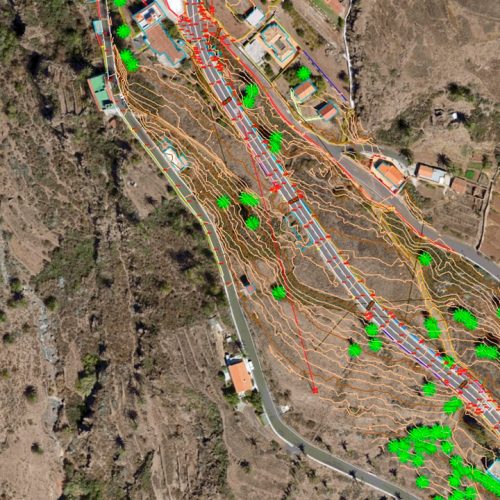
Photogrammetric restitution and topographic survey – “Paredes – Alajeró – Airport of La Gomera”
Topography and Civil Engineering
view
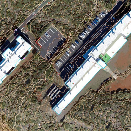
Photogrammetric flight with unmanned aerial vehicle – Roque de los Muchachos Observatory
Topography and Civil Engineering
view
  • COMPANY
  • TECHNOLOGY
    • State-of-the-art technology
    • Mapping and aerial photogrammetry
    • Laser Scanner
    • Lidar
    • Mobile mapping
    • ortOsky
  • SERVICES
    • Versatility
    • Topography and civil engineering works
    • Engineering – construction – town planning
    • Power Lines
    • Mining quarries
    • Precision farming
    • Spatial Planning (G.I.S)
    • Environment
    • Forest Applications
    • Landscape Applications
    • Photographic And Audiovisual Works
  • PROJECTS
    • Precision farming and Environment
    • G.I.S. town and country planning
    • Engineering and Town Planning
    • Power lines
    • Mining and Quarries
    • Topography and Civil Engineering
  • CONTACT
    • +34 669 933 536
    • +34 682 639 939
Copyright @ 2017 GEODRON. All rights Reserved.

Tenerife – Canary Islands – Spain

Enabled by AESA (State Aviation Safety Agency) as Spanish Drone Operator company

Legal warning – Privacy Policy – Cookies policy